THE CROSSROADS OF THE WEST
Marking Historic Trails
The heart of OCTA's historic trail preservation program is the identification and marking of historically significant 19th century emigrant wagon trails. Beginning in 1982, the year OCTA was founded, an on-going effort has and is being made to map and mark three National Historic Trails and their alternate routes—the Oregon National Historic Trail, the Mormon Pioneer National Historic Trail, and the California National Historic Trail. White Carsonite posts (visible in the accompanying photographs) are used with identifying logo and trail name decals. The California-Nevada Chapter and the Utah Crossroads Chapter have also placed, and are placing, heavy rail posts at selected sites and segments. Trail marking posts are placed on trail segments and at historic trail sites that have been identified and verified by historians and cartographers who have studied and mapped the trail routes.
Trail routes go through private, state owned and federal public lands. Permission to place the OCTA trail markers must be obtained from the owners and agencies who own or are responsible for management of public lands. OCTA and the state chapters work with land owners, state and federal agencies and other historic trail organizations to identify, map, mark and protect the last remaining vestiges of these historic wagon trails and historic trail sites. Utah Crossroads works closely with the Long Distance Trails Office of the National Parks Service, the regional offices of the Bureau of land Management, the Utah State Department of Natural Resources Division of Parks and Recreation, and the Utah Historic Trails Consortium. Owners of private and corporate property on whose land historic trail routes cross are advised and consulted when pristine trail evidence such as wagon wheel ruts, swales, and trail landmarks are threatened by cultivation, corporate exploration or development.
The white Carsonite posts and decals used in the trail marking program are purchased with OCTA's Trail Committee funds, or are financed by the National Park Service under a Challenge Cost-Share Program agreement. The Cost-Share Program provides NPS funds for the purchase of trail mapping and marking materials for approved projects. OCTA's share of approved projects is met through volunteer labor hours and mileage.
Utah Crossroads has mapped and marked the California Trail alternate routes in Utah—the Hastings Cutoff and Hensley's Salt Lake Cutoff. The Mormon Pioneer Trail and California Trail west of Fort Bridger to the Salt Lake Valley has been marked with white Carsonite posts by the Utah Crossroads and Wyoming chapters of OCTA. As a result of ongoing trail research by historians and trail enthusiasts, the work of mapping and marking historic trails and their variants is a constant process. Regrettably too, trail markers and interpretive panels are often damaged or destroyed by vandalism. As a result, marking trails will never be a completed project. OCTA volunteers give generously of their time, talents and resources to map, mark and preserve historic wagon trails and trail sites.
-Al Mulder
Discover below the many trails presently marked and our mission TO continue to Mark and PRESERVE THE historic Pioneer TRAILS!
Like to join Us? Click here to become a member!
Trail Marking Gallery
Saving our Trails and Preserving History
Getting out and marking the trails is both a lot of effort and a lot of fun. Usually done on a Saturday, plenty of preparations go into being ready to place the right monument in the right place. Here are a few photographs from recent trail marking activities. The locations are remote and you can see that it can take a lot of hands to do the job right. Join us some time for a day of trail marking and come away tired but satisfied you have helped preserve a priceless part of America's heritage.
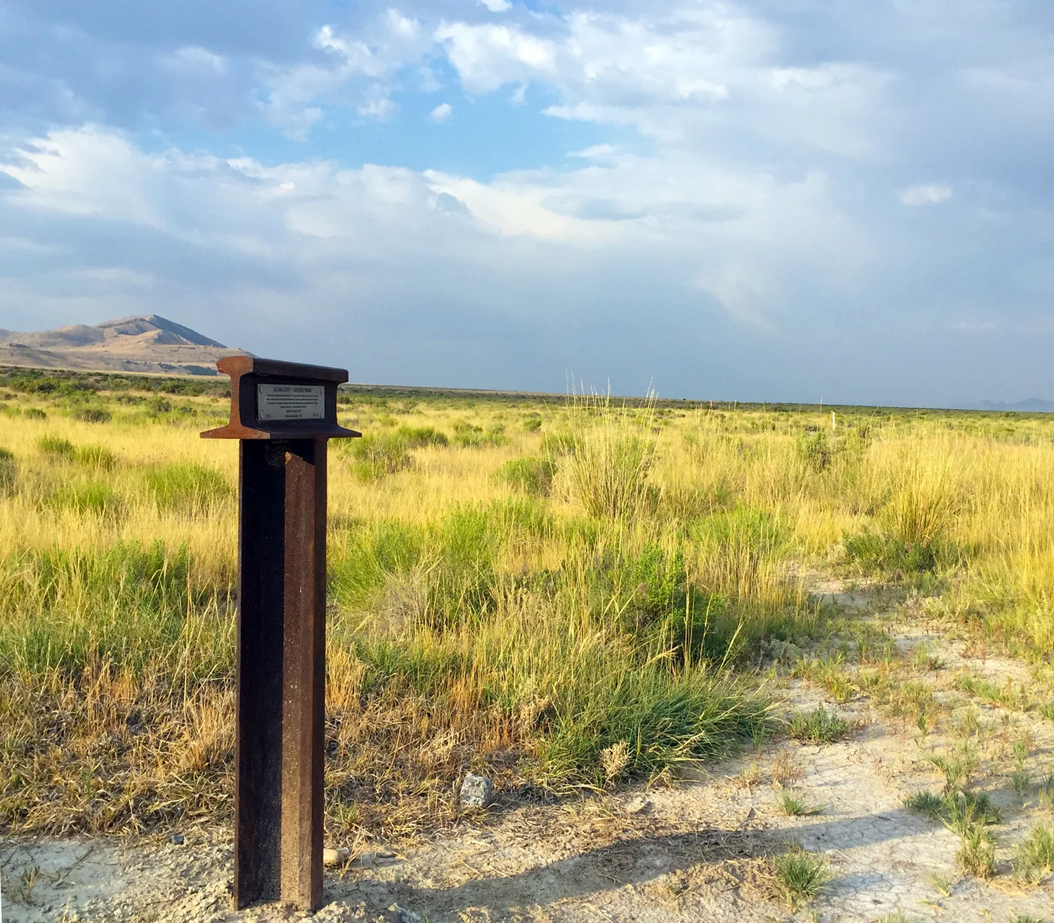
Hastings Cutoff Trail, Aragonite, UTAH
West of the beautiful Grassy Mountain and near eastbound Interstate-80. Note: barbed wire fence in lower left. - Photo by Al Mulder
Placing Post at Lakepoint, UTAH
Here an "Iron Cross"—a sturdy marker made from steel rail is placed along the Hastings Cutoff of the California Trail. The Donner-Reed Party used this portion of the trail and it is often given their name. There is a possibility, currently under investigation, that graves from early in the trails era are near this spot.
Lunch - Timpie Point, UTAh
This marker is not on the trail per se but is on a bench a few hundred feet above the valley floor at Timpie Point. This is the place many historians believe fur trapper and explorer Jedediah Smith came in 1827 after crossing Nevada from California and first caught site of his beloved Great Salt Lake and Wasatch Mountains. For this party of trail explorers and markers it was the perfect place for lunch. Left to right are George Ivory, Greg Childs, Vern Gorzitze, Mike Tea, Boyd Blanthorn, Roy Tea, Ed Otto's son Wes, Jeff Carlstrom, Oscar Olson, Ed Otto and Steve Berlin. Larger (300K) version photo, click here.
Mormon Pioneer/CA Trail, Coyote Creek, Wyoming
Placing a Carsonite marker on the Mormon Pioneer/California Trail at Coyote Creek, Wyoming. Note the special tool for sinking the marker into the ground. - Photo by Al Mulder
Placing Post Near Grantsville, UTah
Vern Gorzitze, OCTA board member, and Jeff Carlstrom, Crossroads Archeology chair, wrestle one of the the heavy steel markers into place. A tractor was used to bore the holes, heavy stones were placed and concrete was made at the sites to anchor the posts permanently. The manpower came in very handy for accomplishing all the necessary tasks.
Salt Desert Near Donner Spring, UTah
Marking the Hastings Cutoff / Donner-Reed / Great Salt Desert Trail. Donner Springs and Pilot Peak are in the background. These last ten miles of the trail before reaching water after traveling nearly a hundred miles without a well or watering hole were the scene of great suffering by the pioneers and their animals. Nevertheless, hundreds made it across this portion of the cutoff before its reputation for extreme hardship made it fall out of favor even with those looking for the shortest possible route to California.
Rocky Ford, Malad River, UTAH
Rocky Ford of the Malad River in Utah near the Idaho border on the Salt Lake Cutoff of the California Trail. Made near Plymouth, UT.
GPS - Near Grantsville, UTah
Ed Otto, Crossroads Preservation Officer, uses a handheld GPS unit to record the position of this marker. GPS promises to significantly improve our ability to map the trails and locate cultural resources and monuments. Stainless steel plaques have been prepared with brief histories of the trail in the area of each marker. They are riveted to the crosswise piece of rail and are expected to be both informative and resistant to vandalism.
Placing Marker at Salt Desert, UTah
Utah Crossroads Chapter members placing Carsonite posts on the Salt Desert Trail (Hastings Cutoff and Donner-Reed road) East of Silver and Floating Islands. Travel back in time and experience the adventure as three interns retrace the fateful steps of the Donner-Reed Party, traveling the ninety-mile waterless stretch of the California Trail known as Hastings Cutoff. This alternate route included this section across the southern end of the Great Salt Lake Salt Flats.
Central Overland Trail - Boyd Station
"At Boyd Station there is a well 12 feet deep." - Cornelius Prather 1862
"Left camp at [Fish Springs] at seven o'clock. Drove on to the first station [Boyd Station]." - Albert Jefferson Young 1862
Hasting Cutoff - Donner/Reed Pass
"Got to the rock of misery, 65 miles, our water all gone and our horses nearly famishing for water Teams giving out, men lying by the side of the road in the hot sun speechless for the want of water." -Henry S. Bloom, August 2, 1850
BIDWELL/BARTLESON tRAIL - TENMILE SPRING
First Overland Emigrant Party "... 5 miles took us to this place, where we found, to our great joy, an excellent spring of water and abundant grass. Here we determined to continue, "till the route was explored to the head of Mary's River..." - John Bidwell, August 27, 1841.
Hastings Cutoff - Echo Canyon, Utah
"Traveled 16 miles today and camped on Echo Creek. A berry resembling a Black-Currant grows here in great quantities."
- William Edmundson, July 31, 1850
Hensley/Salt Lake Cutoff - Deep Creek
"Very bad grass here; Left as soon as we got breakfat. Came to Deep creek crossed and hunted for grass, and found none until we came to the sink of same creek, though we halted a few minutes in the dryest poores grass of the whole world" - William Quesenbury, July 19, 1850
Bidwell/Bartleson Trail - Separation
"After travelling 6 miles this morning the Company came to a halt. The Oregon Company were now going to leave for Bear River for Ft. Hall,...here included to go into Oregon so that the California Company now consisted of only 32 men and one woman and child, there being but one family. The two companies, after bidding each other a parting farewell, started and were soon out of site." - John Bidwell, August 1841.
Pilot Peak, UTah
Pilot Peak is part of the 1846 Hastings Trail. The Donner party traveled this route. The few who came through this dangerous trail used Pilot Peak as a guide across 80 waterless miles.
Bidwell/Bartleson Trail - Triangle in the Plain
First Overland Emigrant Party. "Marched off in a N.W. direction, and intersected our trail of Thursday last, having made a complete triangle in the plain" -John Bidwell, August 21, 1841
Bidwell/Bartleson Trail - Malad River
"Travelled but a short distance when we discovered that a deep salt creek prevented our continuing near the river. In descending this stream in search of a place to cross it, we found on its margin, a hot spring, very deep and clear." - John Bidwell, August 1841.