
STORIES OF PIONEER TRAGEDIES AND TRIUMPH
HISTORY OF THE TRAILS
Utah as a Trails Crossroads
The historic trails that conducted emigrants from the East to the western regions of what is now the United States should not be thought of as discrete and unvarying roads like modern highways. Rather, they were trail systems with alternates, cutoffs (shortcuts), variants, branches and segments that could change fluidly depending on the pioneering of new routes and the circumstances of the emigrants. Travelers often adjusted their intended path to meet changing needs for speed, resupply or even safety.
Modern-day Utah occupies a unique position in the western trails system. Because of its geography and relatively early settlement, Utah is a literal trail crossroads. The Spanish trail made a broad upward loop through Utah as it conducted travelers between California and New Mexico around the canyons of the Colorado River. Indians, mountaineers, fur trappers, traders, explorers and adventurers passed through the state on east-west and north-south routes, often leaving trails that others followed. Utah is the western terminus of the Mormon Trail.
The California Trail had important alternates through Utah, the Hastings Cutoff passing south of the great Salt Lake and Hensley's Salt Lake Cutoff which connected Salt Lake City with the California Trail northwest of the lake in Idaho. Throngs of Forty-Niners as well as more conventional travelers took these routes. Emigrants bound for Oregon sometimes passed through the state. The Pony Express crossed Utah and in some places was contiguous with portions of the California and Mormon trails. The eastern and western segments of the first Transcontinental Railroad were joined here. Utah is truly a trails crossroads.
In the descriptions that follow, contributors from the Utah Crossroads Chapter present general sketches of the major trails and additional detail about regional trail segments.
DISCOVER UTAH NATIONAL HISTORIC TRAILS GUIDE VIRTUAL TOUR AT NPS! CLICK THE MOBILE MAP BELOW TO LEARN MORE.

Click the Photos and Maps to see a larger image.
NATIONAL HISTORIC TRAILS AUTO TOUR ROUTE INTERPRETIVE GUIDE UTAH —CROSSROADS OF THE WEST. Discover the four trails that exist within our UT chapter boundaries with a "National Historic Trails" designation-by federal law. They are California, Oregon, Mormon and Pony Express. Learn about the pioneers and their perilous journeys as the traveled the trails through UTAH.
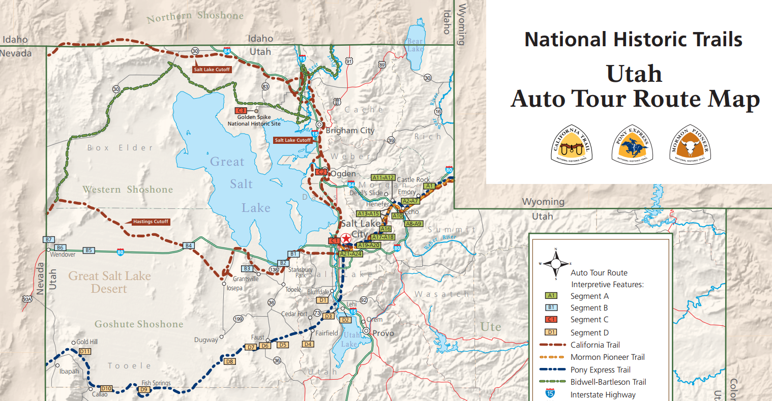
The Utah Auto Tour Route Map accompanies the Auto Tour Route Interpretive Guide.
DISCOVER THE HISTORY OF THE OREGON TRAIL! More than 2,000 miles of trail ruts and traces can still be seen along the Oregon National Historic Trail in six states-reminders of the sacrifices, struggles, and triumphs of early American settlers. - NPS
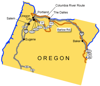
Utilize the Auto Tour Route Interpretive Guide for the Oregon Trail! Plan your trip and download the Oregon National Historic Trail Topographical Map and check out the Interactive Trails Map Viewer at NPS!
Gold Fever! Follow in the footsteps of over 250,000 emigrants who traveled to the gold fields and rich farmlands of California during the 1840s and 1850s-the greatest mass migration in American history. In excess of 25,000 gold seekers came through Salt Lake—stopping for provisions and to trade animals. More than 1,000 miles of trail ruts and traces can still be seen across 10 states on the California National Historic Trail. - NPS

Discover Interactive Maps for all of the trails at the National Park Service website.
Learn how young men once rode horses to carry mail from Missouri to California in the unprecedented time of only 10 days. This relay system along the Pony Express National Historic Trail in eight states was the most direct and practical means of east-west communications before the telegraph. - NPS

Discover driving directions to follow the Pony Express National Historic Trail west through Utah at NPS. Plan your trip by downloading the Pony Express National Historic Trail Topographical Map and explore the trail with the NPS Interactive Trails Map Viewer.
An Exodus - The Mormon Pioneer Trail: Few years in the Far West were more notable than 1846. That year saw a war start with Mexico, the Donner-Reed party embarked on their infamous journey into a frozen world of indescribable horror, and the beginning of the best-organized mass migration in American history. The participants of this migration, the Mormons, would establish thriving communities in what was considered by many to be a worthless desert (NPS.) In addition, 4 small groups came through the Salt Lake Valley taking what is known as the Hastings Cut-off across to the Humbolt River. In 1847, the Mormons came in large numbers.

Download or view the PDF map at NPS to see details of the Mormon Pioneer Trails and read about their journey along the trail. Once the map is accessed, click the + sign repeatedly in the bottom left corner to enlarge the map.
View the Hensley Salt Lake Cutoff Trail Documentary and learn all about the Bidwell/Bartleson Trails. The California Trail had important alternates through Utah, the Hastings Cutoff passing south of the great Salt Lake and Hensley's Salt Lake Cutoff which connected Salt Lake City with the California Trail northwest of the lake in Idaho. Most California emigrants went north of Utah to Ft Hall on the Snake River. They cut southwest crossing through a few miles of what is now the northwest corner Utah.
Discover Utah History to Go for more information about the the pioneers who traveled the Hensley Salt Lake Cutoff Trail.